After paddling the Toccoa Saturday, I hadn't planned on paddling the next day "unless somebody was paddling something good." As is usually the case for me in the winter, I was having trouble getting motivated to put on gear that would no-doubt still be wet the following day. I had planned to hang around the house watching football until I checked my voice mail and had a message about a group going to the Locust Fork of the "Black" Warrior River in Northern Alabama. This was a chance I wasn't going to miss as I had never run it and it had been on my list for several months. I'm always a sucker for a new run so I called back and said I was in.
Hal Tutor, Guy Watson, and Lois Newton would be arriving from Middle Tennessee and I would be coming in from North Georgia . . . after a good bit of mapquest confusion and some debate about whether it would be easier to meet at the put-in or at the take-out we finally hit the road with hopes of making a rendevous around 11 AM Eastern, 10 Central. Everybody ran late but it was OK because both vehicles were late by about the same amount of time. Situation normal . . . (fill in blanks).
When we all finally got there, the air temperatures were warm and the gauge was reading around 3.2 at the 231 bridge. This turned out to be a good level for a first run.
Setting shuttle is actually easier than it sounds from reading the available internet sources and we got everything together and launched into the river with relatively little discussion about specifics. All I knew was that at that level, the run was supposed to be mostly class II with a couple of IIIs on it, one of which is sometimes considered to be a IV.
The first thing I noticed about the Locust Fork was that it didn't remind me of any other river. This is unusual because I have gotten used to seeing all of the different archetypes of Southern Appalachian runs. Usually when I go somewhere new, the river or creek fits into some particular category that I have seen before. Not so with the Locust Fork. The geology and flora of North-Central Alabama are quite distinct from the mountain provinces of Tennessee, Georgia, and North Carolina.
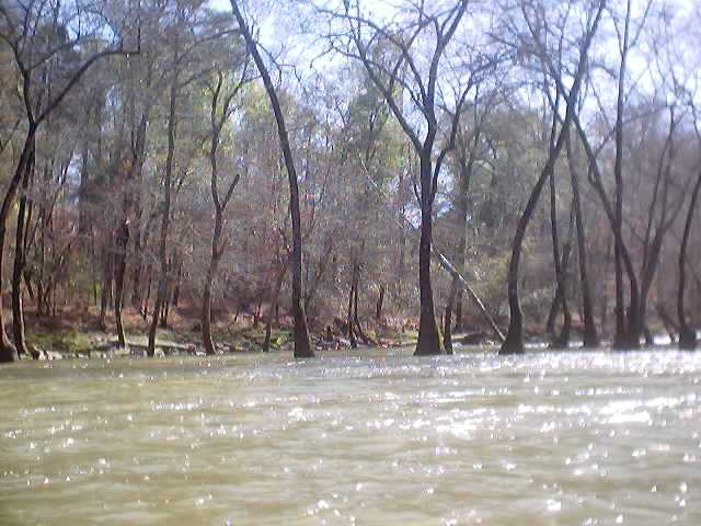
"Swamp Trees" in the Locust Fork. The species is actually Water Tupelo.
There were very few Rhododendrons. I didn't see any Hemlocks in the ravine, although there was some other type of needled evergreen that looked like a sub-tropical species. Finally, there were trees growing IN the water. I don't mean like on the Upper Ocoee where the trees normally aren't in the water. These were some type of swamp tree with great big root balls sticking out of the water. It was like paddling a swamp river that had whitewater on it and it was a strange sight for my eyes. We actually had to dodge around some growing trees while running rapids. Normally that only happens at flood stage.
After you peel out, there is a quick class II wave train that appears to have been altered by bridge construction. It's easy enough but I wouldn't want to flip over as it is apparent that a bunch of riprap has spilled into the riverbed. After this the river quickly establishes an impression on you. It runs through a relatively shallow ravine that is lined mostly with hardwoods. You get the impression that you are at relatively low elevation for a whitewater run. Occasionally the river gorges up a bit and there are a few sheer rock walls that may be as much as 150 to 200 feet high, usually on bends in the river.
Everywhere there are signs of civilization. Although we only saw a few houses, the riverbed and banks were lined with garbage, balls, lawn furniture, etc. Occasionally you will see some power lines or bits of junk higher up on the walls of the ravine. Once, we could smell the strong odor of a pig farm and knew that there must be one just over the top of the cliffs. I tried not to think about the runoff.
The character of the run is long pool and drop, with most rapids being of the shoal and wave train type . . . but there are a few ledges and pour-overs. There was a good bit of wood in the run. Since the riverbed is fairly wide, this usually wasn't an issue for us, but this river has an abundance of sieve action along the sides of the main channel and most of the rock piles are full of logs and branches. Some of these were still in play even with the modest water level and I imagine they get to be a major issue when the level is higher.
We got to see an ugly little display of what can happen with a sieve when we finally got to the first significant rapid, Double Trouble (III- at this level). This rapid consists of two distinct drops, the first being a sloping drop with several rocks to dodge, including one that makes a nasty little pour-over in the middle at the bottom. There is then a short stretch of perhaps 30 or 40 yards of swift current followed by a small ledge that reputedly has a submerged sieve on the right. For sure there is another giant non-submerged sieve to the far right and this is where we got to see how it can be a problem. Fortunately it didn't involve our group as we had all gotten out to scout and to eat lunch on the rocks.
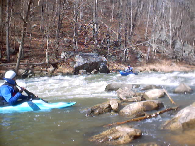
Lois Newton running Double Trouble. From a different trip February 25, 2007.
Two paddlers came down the river in Transformers and got out to scout the rapid. It seemed as if there was one beginner and one experienced paddler. After they got back in their boats, the seemingly experienced paddler went first and eddied out between the two drops to wait for the beginner to come down. When the beginner entered the rapid, he went way too far right on the first drop, failed to paddle and ran straight into the pour-over rock at the bottom. This precipitated falling sideways into the hole, flipping, and a panic swim. Let the terror begin.
At this point the experienced paddler starts to come to the rescue. He gives the swimmer instruction as to how and where to swim and starts trying to gather up gear. Mind you, the swimmer is still headed downstream where there are two known sieves, one of which is obvious and large.
The swimmer eventually gets into an eddy and his buddy is trying to push his boat over but loses it. The result is that the boat started heading toward the non-submerged sieve, which is full of logs by the way. While in the process of doing this, the only guy still in his boat flips over . . . right in front of the logged-jammed sieve. He misses his roll and comes out of his boat.
By now, the first loose boat has already gone into the sieve and is seemingly firmly wedged. The would-be rescuer turned swimmer now realizes his life is in danger and has the sense to swim away from the sieve, but in doing so, he now swims around a blind turn that leads behind the pile of boulders that forms it. We could clearly see at least one log in the channel, although it appeared to be possible to swim under it.
I couldn't believe my eyes and was trying to decide whether to start making my way down the bank or go back up to my boat. I was positioned on the wrong side of the river to do anything so it seemed like it would be best to get in my boat. The first swimmer seemed safe but it took a long 20 seconds or so before I finally saw the second swimmer stand up behind one of the boulders and tell his buddy that he was OK.
That's the closest I've ever seen anyone come to swimming into a sieve. The second swimmer's boat had followed him down the blind channel but the first guy's boat was still stuck in the logs. By now, Hal Tutor has started saying that they were going to need help and we all made haste back up to our boats, upstream of the island to run the rapid and assist.
Hal was the first to launch and ran right down the rapid but I didn't see how he had run it so I just set myself up on river right to follow a right to left diagonal down the drop, avoiding a pour-over on river right and moving to the left of the pillow and pour-over at the bottom center. I planned to eddy out half-way through the rapid on the left.
Looking downstream, it appeared to me that Hal was merely eddied out and was not participating in a rescue. I knew this must mean that everything was OK down below. I also could no longer see the boat stuck in the sieve but I thought it was only because I was looking from a different angle.
When I saw that Guy was ready to go I held my paddle up to see if it was OK to run the rapid. Hal responded and I peeled out and entered the rapid just right of center, bouncing through a couple of small holes and adjusting my boat angle further left to avoid the pillow and pour-over at the bottom. When I got about half way down the rapid, I hit a rock while sideways and got a little off-kilter. I flailed for a second or two, then recovered and easily made the move then eddied out on the left half way through the rapid (on the opposite side of the river from the sieves).
Hal was signaling me to stay left on the second drop. I waited for Guy to run the first drop successfully, then peeled out and slid down the left on the second drop, which was quite easy.
The swimmers had recovered already and had both boats. After making sure there wasn't anything seriously wrong, I turned my attention back upstream. Lois had apparently decided not to run the drop so as to not potentially add to the carnage. I'm sure she could've run it successfully but she decided to play it safe, which can't be criticized. Hal got out of his boat to help her carry her canoe to the bottom.
I paddled down to talk to the swimmer guys and one of them told me he had pulled the pinned boat through the sieve from the downstream side. These two guys were very lucky. One or both of them could've ended up in one of the sieves surrounding the large boulders on river right at the bottom. If the water level had been higher and pushier, I think the situation could've been fatal. That said, at Sunday's water level, the drop really was a marginal class III and experienced intermediate paddlers can probably avoid trouble there easily. Less experienced paddlers should consider portaging on river left, which isn't very difficult anyway.
After this we ran a couple more decent class II rapids and ate lunch on a beach on river left. At this point we saw some kids paddle past in creek kayaks looking very inexperienced. It looked like trouble to me.
After lunch we headed down and encountered some more good class II pool-and-drop action. This was interrupted by the ugly odor of a pig farm that was obviously right at the top of the overhanging cliffs. We paddled on, ran a good wave train rapid and the odiferous scent disappeared.
Eventually we came upon the inexperienced kids in a rapid and one of them was swimming. We assisted with the rescue and Hal determined that they might not survive if we left them so he invited them to join us and started giving some basic instruction. It turns out that they had just gotten kayaks for Christmas and this was their first day on the river. Although the air temperatures were probably around 70, the water was surely in the 40s and they were basically wearing rash-guard swim wear intended for the summer. Hypothermia was a realistic threat. What followed was a series of class II swims and rescues. The boys had "rafted the Locust Fork many times" and were going through that familiar process of realizing that kayaking is much, much more difficult than rafting.
We got to enjoy some more scenery, with steep cliffs lining the river periodically, accompanied by very high quality class II and II+ rapids, some of which were quite technical. Although it was mostly class II, a few of the holes were strong and I would like to see them at higher levels.
Finally we approached Powell Falls, probably a class III or III+ when the gauge is at 3.2 (see photos). Powell Falls is a river wide ledge that drops about 6 to 8 feet and is separated (at lower levels) into two distinct channels by a rock island in the middle, which is an excellent spot to scout or portage if necessary.
The normal line at Powell is approximately in the middle of the river right channel and is a slide onto a boof ledge that lands in a good pool. More swamp trees are growing in the middle of the river below, adding to the strangeness of things if you are from further up in Appalachia. Everyone except Hal decided to walk it, although I looked at it for a long time and only made the decision to walk after seeing him run it.
Hal and Guy, who had run the river before, but not recently, discussed and agreed on the proper line, and Hal finally peeled out very high and lined himself up. He entered just to the right of a small roostertail at the top of the slide, a little too far right as it turns out. After he slid down a ways, he got canted over and bounced off some rock on the boof ledge before landing in the pool listing to his port side. He braced back up and grinned (check out the sequence of photos on the right). After seeing him bounce hard on the rock, my mind was made up. I decided to walk it. No need to break my playboat on a class III+ slide.
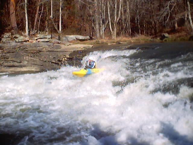
Kenny Warwick running Powell Falls on a different trip, February 25, 2007. Turned out to not be a good line. A little too far to the right. Bouncing and trouncing followed . . . but no swim.
Unfortunately I started regretting not having run it almost as soon as I launched in the eddy below. I often skip the big drops on my first run down a river and then spend months or years waiting to go back and run the drop. If I had been in my creek boat, I think I would have run it. In retrospect, it really is just an overgrown version of Blackberry Falls on the Cartecay and doesn't look too difficult as long as you are in the right spot.
We paddled on down and shortly came up on the last rapid of significance, Ender Hole, which is literally within sight of the takeout bridge. Hal and I were in playboats and decided to try the hole. Hal immediately went in and did some cartwheels. I immediately tried to go in but my instinctively defensive paddling prevented me from getting onto the foam pile. This cycle repeated many times with Hal doing more cartwheels and me failing to make the odd ferry move through a small hole, across a green tongue, and onto the pile. It was harder than it looked, even after I started being more aggressive.
Hal finally got tired and presumably cold from flipping over and began egging me on to get into the hole. I finally pulled it off, side surfed for a second, whipped around into a fair front surf, and then buried my paddle behind the pile and pulled off grinning. Having gotten into the hole, I was also tired and hungry and decided to call it quits. It had taken me perhaps 10 or 12 tries to get in the hole. We all paddled on to the takeout.
The takeout is on river right at the 160 bridge and isn't very much fun. There is a good hiking trail next to a pretty waterfall on a tiny tributary. The distance is maybe only a hundred yards or so but unfortunately you have to climb about 50 vertical feet, so your calves will be burning by the time you get to the top. We made a team effort of hauling up Lois's canoe and finally everybody got loaded up just as darkness was descending. It was a great trip!
The only significant drawbacks were the abundance of trash lining the riverbanks and in the river bed. It is a river that bears the burden of being downstream from too much civilization and suffers from a lack of protection.
The Locust Fork has high quality whitewater on it, and at the water level we had that day I would say it is equivalent to or maybe just a slight step up from the Nantahala Gorge, although in many ways it is more forgiving than the Nanty due to it's pool-and-drop nature. Most of the pools are very long so there is plenty of time to rest and recover between drops.
It was a little strange to paddle a river with few evergreen bushes and trees, although the numerous swamp trees growing in the riverbed adds some interest. This was a stark contrast with my familiar runs from the high Appalachians. Nonetheless, this is a great winter run and it's about the same distance from my house as the Nantahala, so I will be back soon, hopefully with a higher level in the river.