Hiwassee River - Hayesville to the Fires Creek Confluence
North Carolina
May 19, 2007
Author's Note: This river's name is frequently spelled "Hiawassee" in some areas. I have left out the letter "a" to indicate to the reader that this is actually the same river as the (very popular) stream that flows through Reliance, Tennessee, and because that is how I think of it.
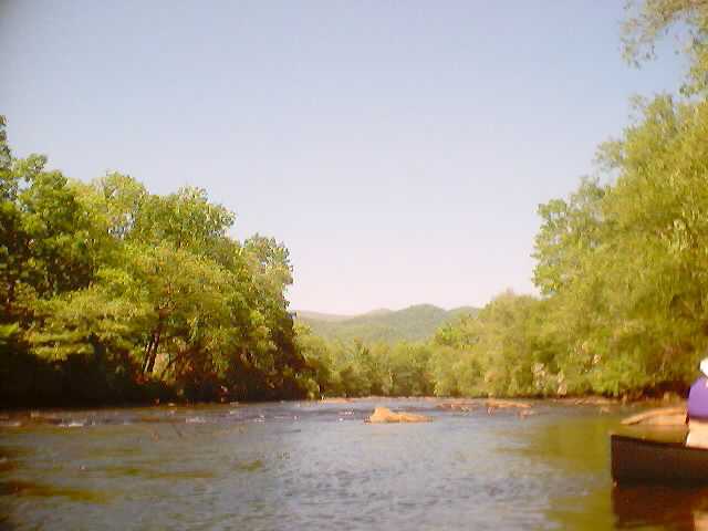 A boulder garden on the Hiwassee River with the Southern Appalachians in the background. A boulder garden on the Hiwassee River with the Southern Appalachians in the background.
I was sick most of the week but since I had gone back to work on Friday, I couldn't see any reason to stay home Saturday. Especially since I got the chance to explore another new run, and it's one that's been on my target list for about two years: a section of the Upper Hiwassee above Lake Hiwassee.
The Hiwassee is familiar to most paddlers in the Southeast region as a beginner run in the gorge below Apalachia Dam, but the Hiwassee is a large river with a huge watershed and there are several other runnable segments. The most well-kept secret is probably the Dries section, which is a rarely run class III-IV wilderness segment, but there are also many miles of class I-II above Hiwassee and Apalachia Dams and it was the latter that we had in our sights. The stretch we headed for is below TVA's Chatuge Dam.
We met up in the metropolis of Ranger, North Carolina (with it's single stoplight). On the way there I had to wait for a red light in Ducktown, Tennessee, which proves that the entire world is being developed. Someday there are going to be traffic signals and truck stops with McDonalds in them all along the Appalachian Trail. Anyway, we headed from there through Murphy and down Highway 64 even further into rural Far Western North Carolina (FWNC).
The crew consisted of Steve and Carrie Smyth, Lois Newton (plus her two dogs Jack and Peanut), Betsy Westerfield and her brother John Maher, and the author. Kayaks had the upper hand although the number of paddlers was equal for both teams with Steve and Carrie tandem and Lois and her two dogs also in a canoe. Everybody else was in kayaks and it was John's first time in a kayak, although he was experienced with inflatables and sit-on-tops.
Nobody in the group had ever run the section, although Steve Smyth had scouted out potential put-ins and take-outs and we both had paddled a section of the Hiwassee just downstream as part of a creeking expedition over the winter. This is one of my favorite situations: nobody knows what's coming. This makes it into an exploratory type run, which is fun even if it's only class I-II.
We finally decided to launch just off the highway in Hayesville where we received permission from a gas station to use their parking lot next to a road bridge. It wasn't too bad of a launch although it was a little hard for the beginner to get in the kayak there for the first time. Below was a tree-lined section with a few houses and a whole bunch of logs and strainers. We instructed John on the avoidance of wood and everybody headed downstream at a leisurely pace. After a short distance a major stream comes in from the right, adding some flow. Steve thinks it was probably Tusquitee Creek.
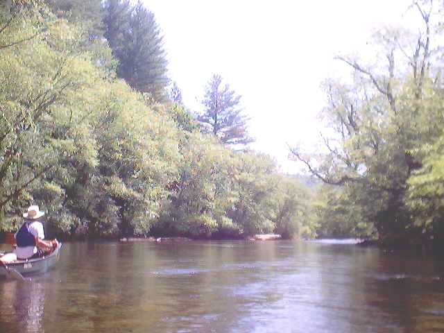
A typical view of the Upper Hiwassee River. In the canoe: Steve Smyth.
The first couple of miles were pretty nice. Despite drought conditions, there was plenty of water and we encountered a few class I to I+ shoals with maybe an isolated II-. It was easy to get stuck but if you picked your lines carefully you could usually slot your way through with a minimum of hull damage. Some parts of the river in this stretch are heavily wooded and we all discussed the absolutely spectacular display being put on by the blooming Mountain Laurel this year. I wondered if it has something to do with the very dry conditions.
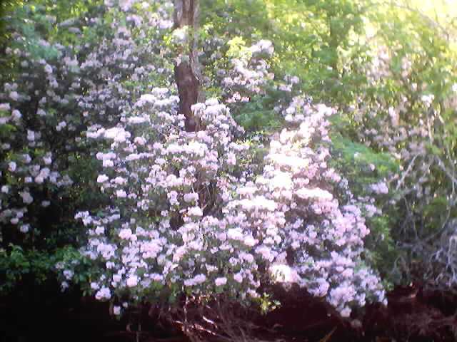
At times it seemed like we were walled in by Mountain Laurel in full bloom.
There were various waterfowl all along the river in this stretch. We saw numerous Mallards and a lot of Canada Geese. We also saw an assortment of other wildlife at various times, such as Kingfishers and a beautiful hawk soaring over a meadow near the takeout. The forest ranged from deciduous to pine and hemlock. The banks were lined in places with walls of Rhododendron and Laurel. Everybody agreed it was a beautiful run and the farther we got from town, the more beautiful it became.
Unfortunately after another creek or two came in the riverbed began to widen to the point that the water was spread a little too thin. We were warned by a friendly local who said that it was about to get really shallow ahead and he was right. The last two miles became what Steve termed "a beatfest." It really was too low. I still managed to not get out of my kayak but only by exhausting myself and leaving about a pound of plastic on the rocks of the Hiwassee riverbed.
We finally got to the takeout exhausted from the rocky last couple of miles, glad to be off the river. I would have to say that it was still well worthwhile to paddle, if for no other reason than that I had not done it before and now I get to cross it off my target list. The extreme drought that we are currently experiencing has caused me to lower my threshold for low water runs. But I think it would be best to either paddle it with more natural flow or wait for a sustained release from Chatuge Dam. Unfortunately the TVA Operating Guide is currently indicating that the level in the lake is well below normal for this time of year so I don't think we can expect sustained releases anytime soon. Still, it's a good class I-II run and should be given consideration for a wetter year.
|